
Make a donation
Gear up for your next adventure:
As an Amazon Associate, this site earns from qualifying purchases at no extra cost to you.
Santa Catalina Island topographic map
Click on the map to display elevation.
Make a donation
Gear up for your next adventure:
As an Amazon Associate, this site earns from qualifying purchases at no extra cost to you.
Santa Catalina Island
Santa Catalina Island (Spanish: Isla Santa Catalina; often shortened to Catalina Island or Catalina, and also known as Pimu as the traditional name of the Indigenous people of the Tongva Tribe) is a rocky island, part of the Channel Islands, off the coast of Southern California in the Gulf of Santa Catalina. The island covers an area of about 75 square miles (194 square kilometers). It features a diverse and rugged landscape, including rolling hills, canyons, coastal cliffs, and sandy beaches. The island's highest peak is Mount Orizaba, rising to an elevation of 2,097 feet (639 meters). The island is 22 mi (35 km) long and 8 mi (13 km) across at its largest width. The island is situated in the Pacific Ocean, approximately 29 mi (47 km) south-southwest of Long Beach, California. Politically, Catalina Island is part of Los Angeles County in District 4. Most of the island's land is unincorporated and is thus governed by the county.
Make a donation
Gear up for your next adventure:
As an Amazon Associate, this site earns from qualifying purchases at no extra cost to you.
About this map
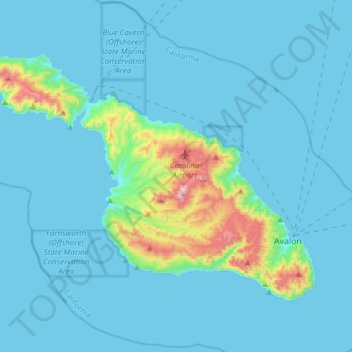
Name: Santa Catalina Island topographic map, elevation, terrain.
Average elevation: 60 m
Minimum elevation: 0 m
Maximum elevation: 637 m
Make a donation
Gear up for your next adventure:
As an Amazon Associate, this site earns from qualifying purchases at no extra cost to you.