Geolocate

Chino topographic map

Click on the map to display elevation.

About this map

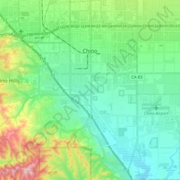
Name: Chino topographic map, elevation, terrain.

Location: Chino, San Bernardino County, California, United States (33.92390 -117.73550 34.04834 -117.59932)

Average elevation: 239 m

Minimum elevation: 148 m

Maximum elevation: 508 m

Other topographic maps

Click on a map to view its topography, its elevation and its terrain.

Earp

United States > California > San Bernardino County

Average elevation: 137 m

Oak Glen

United States > California > San Bernardino County

Average elevation: 1,610 m

Twentynine Palms

United States > California > San Bernardino County > Twentynine Palms

According to the United States Census Bureau, the city has a total area of 59.1 square miles (153 km2), all land. The city is at an elevation of 1,988 feet (606 m). The Marine Corps Air Ground Combat Center Twentynine Palms is located there.

Average elevation: 690 m

Gear up for your next adventure:

🎒Surveyor High-Vis Vests - Multi-pocket safety vests for field professionals
🔋Portable Power Banks - Keep devices charged on long trips
📈Fitness Trackers - Monitor activity and hike metrics
🥛Insulated Flasks - Keep drinks hot or cold
🪑Compact Camping Tables - Tables for campsite comfort

As an Amazon Associate, this site earns from qualifying purchases at no extra cost to you.