
Make a donation
Gear up for your next adventure:
As an Amazon Associate, this site earns from qualifying purchases at no extra cost to you.
Peloponnese Region topographic map
Click on the map to display elevation.
Make a donation
Gear up for your next adventure:
As an Amazon Associate, this site earns from qualifying purchases at no extra cost to you.
About this map
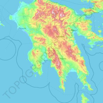
Name: Peloponnese Region topographic map, elevation, terrain.
Average elevation: 229 m
Minimum elevation: -5 m
Maximum elevation: 2,314 m
Make a donation
Gear up for your next adventure:
As an Amazon Associate, this site earns from qualifying purchases at no extra cost to you.
Other topographic maps
Click on a map to view its topography, its elevation and its terrain.
Gouves
Greece > Peloponnese, Western Greece and the Ionian > Laconia Regional Unit
Average elevation: 245 m
Aigio
Greece > Peloponnese, Western Greece and the Ionian > Achaia Regional Unit
Average elevation: 371 m
Ancient Olympia
Greece > Peloponnese, Western Greece and the Ionian > Elis Regional Unit
Another location that has a special interest to both ancients and moderns is the stadium. It is basically a field with start and end lines marked off by transverse curbing. The athletes entered under an archway of a vaulted corridor at the start. Spectators sat mainly on the field's sloping flanks. The length…
Average elevation: 99 m
Olympia
Greece > Peloponnese, Western Greece and the Ionian > Elis Regional Unit > Ancient Olympia
Average elevation: 57 m
Make a donation
Gear up for your next adventure:
As an Amazon Associate, this site earns from qualifying purchases at no extra cost to you.