
Thank you for supporting this site ❤️
Make a donation
Make a donation
Gear up for your next adventure:
As an Amazon Associate, this site earns from qualifying purchases at no extra cost to you.
Detmold topographic map
Click on the map to display elevation.
Thank you for supporting this site ❤️
Make a donation
Make a donation
Gear up for your next adventure:
As an Amazon Associate, this site earns from qualifying purchases at no extra cost to you.
About this map
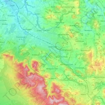
Name: Detmold topographic map, elevation, terrain.
Location: Detmold, Kreis Lippe, North Rhine-Westphalia, Germany (51.85873 8.76308 51.99827 8.98958)
Average elevation: 202 m
Minimum elevation: 95 m
Maximum elevation: 427 m
Thank you for supporting this site ❤️
Make a donation
Make a donation
Gear up for your next adventure:
As an Amazon Associate, this site earns from qualifying purchases at no extra cost to you.