Geolocate

Millbrae topographic map

Click on the map to display elevation.

About this map
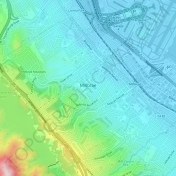
Name: Millbrae topographic map, elevation, terrain.

Location: Millbrae, San Mateo County, California, 94030, United States (37.58145 -122.42495 37.61508 -122.37251)

Average elevation: 66 m

Minimum elevation: -4 m

Maximum elevation: 332 m

Other topographic maps

Click on a map to view its topography, its elevation and its terrain.
Gear up for your next adventure:

🔪Multi‑Tools & Knives - Versatile tools for outdoor tasks
🧯Camp Safety Kits - All‑in‑one safety gear
🥾Women's Waterproof Boots - Gore-Tex protection for trail and mountain walking
🚲Cycling GPS Computers - Topographic mapping for Irish road and mountain biking
🥾Mountaineering Boots - Heavy‑duty boots for rugged peaks

As an Amazon Associate, this site earns from qualifying purchases at no extra cost to you.