
Mobile topographic map
Click on the map to display elevation.
Mobile
According to the United States Census Bureau, the city has a total area of 180.1 square miles (466 km2), with 139.5 square miles (361 km2) of it being land, and 40.6 square miles (105.2 km2), or 22.5% of the total, being covered by water. The elevation in Mobile ranges from 10 feet (3 m) on Water Street in downtown to 211 feet (64 m) at the Mobile Regional Airport.
About this map
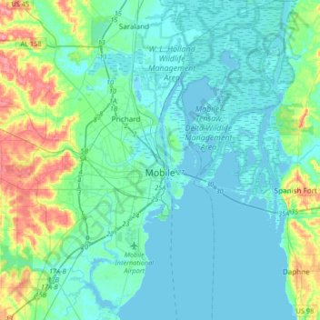
Name: Mobile topographic map, elevation, terrain.
Location: Mobile, Mobile County, Alabama, United States (30.56037 -88.22125 30.84346 -87.95662)
Average elevation: 14 m
Minimum elevation: -2 m
Maximum elevation: 76 m