Geolocate

Finse topographic map

Click on the map to display elevation.

👉 Easily get elevation data in JSON, GeoTIFF and KML formats using Elevation API
Thank you for supporting this site ❤️
Make a donation

About this map

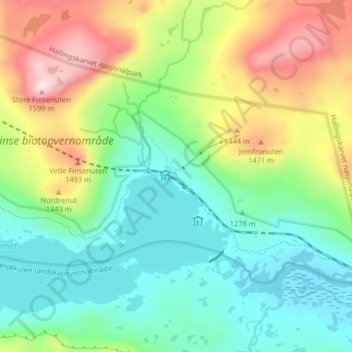
Name: Finse topographic map, elevation, terrain.

Location: Finse, Ulvik, Vestland, Norway (60.58301 7.48202 60.62301 7.52202)

Average elevation: 1,331 m

Minimum elevation: 1,195 m

Maximum elevation: 1,597 m

Other topographic maps

Click on a map to view its topography, its elevation and its terrain.

Vik

Norway > Vestland

Average elevation: 739 m

Gear up for your next adventure:

🎒Technical Hiking Daypacks - Ergonomic backpacks with hydration bladder compatibility
🧶Camping String Lights - Ambience and utility lighting
🎒Fully Waterproof Rucksacks - Submersible protection for river crossings
📱Phone Holders for Biking - Secure phone mounts for touring cyclists
🧯Portable Extinguishers - Safety tools for campfires

As an Amazon Associate, this site earns from qualifying purchases at no extra cost to you.