
Make a donation
Gear up for your next adventure:
As an Amazon Associate, this site earns from qualifying purchases at no extra cost to you.
Kalyani topographic map
Click on the map to display elevation.
Make a donation
Gear up for your next adventure:
As an Amazon Associate, this site earns from qualifying purchases at no extra cost to you.
About this map
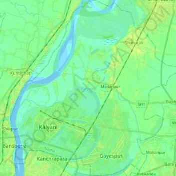
Name: Kalyani topographic map, elevation, terrain.
Location: Kalyani, Nadia District, West Bengal, India (22.93589 88.40191 23.07630 88.54835)
Average elevation: 9 m
Minimum elevation: -3 m
Maximum elevation: 30 m
Make a donation
Gear up for your next adventure:
As an Amazon Associate, this site earns from qualifying purchases at no extra cost to you.
Other topographic maps
Click on a map to view its topography, its elevation and its terrain.
Bidhannagar
India > West Bengal > Bhangar - II
Bidhannagar is located at 22°35′N 88°25′E / 22.58°N 88.42°E / 22.58; 88.42.[7] It has an average elevation of 11 metres (49 ft).
Average elevation: 5 m