
Make a donation
Gear up for your next adventure:
As an Amazon Associate, this site earns from qualifying purchases at no extra cost to you.
Koshi Province topographic map
Click on the map to display elevation.
Make a donation
Gear up for your next adventure:
As an Amazon Associate, this site earns from qualifying purchases at no extra cost to you.
Koshi Province
Koshi Province covers an area of 25,905 km2. The province has three-fold geographical division: Himalayan in the north, Hilly in the middle and Terai in the southern part of Nepal, varying between an altitude of 70 m and 8,848 m. Terai, extended from east to west, is made up of alluvial soil. To the west of Koshi River, in between Mahabharat Range and Churia Range, there elongates a valley called Inner Terai. Churai Range, Mahabharat Range and other hills of various heights, basins, tars, and valleys form the hilly region. Some parts of this region are favorable for agriculture but some other parts are not. The Himalayan region, in the north, consists of many mountains ranges. Mahalangur, Kumbhakarna, Umvek, Lumba Sumba and Janak being some of them. The highest mountain in the world, Mount Everest (8848.86 m); and the third highest mountain, Kangchenjunga (8598 m) also lie in this province.
Make a donation
Gear up for your next adventure:
As an Amazon Associate, this site earns from qualifying purchases at no extra cost to you.
About this map
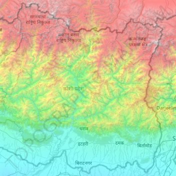
Name: Koshi Province topographic map, elevation, terrain.
Location: Koshi Province, Nepal (26.34776 86.15551 28.11343 88.20153)
Average elevation: 2,208 m
Minimum elevation: 53 m
Maximum elevation: 8,537 m
Make a donation
Gear up for your next adventure:
As an Amazon Associate, this site earns from qualifying purchases at no extra cost to you.
Other topographic maps
Click on a map to view its topography, its elevation and its terrain.
Make a donation
Gear up for your next adventure:
As an Amazon Associate, this site earns from qualifying purchases at no extra cost to you.
Make a donation
Gear up for your next adventure:
As an Amazon Associate, this site earns from qualifying purchases at no extra cost to you.
Simikot
Nepal > Karnali Province > Humla
Lying at an altitude of just over 2,900m on a gentle slope high above the Humla Karnali River, Simikot lies on an ancient trade-cum-pilgrimage route to Mount Kailash. Mount Kailash is located in the Purang County of the Tibetan Autonomous Region, China, which borders Humla district of Nepal to the north. In…
Average elevation: 3,100 m
Mount Everest
Nepal > Koshi Province > Solukhumbu
Mount Everest (Nepali: सगरमाथा, romanized: Sagarmāthā; Tibetan: Chomolungma ཇོ་མོ་གླང་མ; Chinese: 珠穆朗玛峰; pinyin: Zhūmùlǎngmǎ Fēng) is Earth's highest mountain above sea level, located in the Mahalangur Himal sub-range of the Himalayas. The China–Nepal…
Average elevation: 7,850 m
Make a donation
Gear up for your next adventure:
As an Amazon Associate, this site earns from qualifying purchases at no extra cost to you.
Birgunj
Nepal > Madhesh Province > Parsa
Birgunj is located in the Terai plain which is the northern part of the Indo-Gangetic plain. Birgunj metropolitan city has an elongated shape. The variation in altitude is in the range of 78 m to 95 m when moving from south to north of Birgunj. Although the range of altitude variation is small, but there is a…
Average elevation: 88 m