
Lhasa topographic map
Interactive map
Click on the map to display elevation.
Lhasa
Lhasa prefecture-level city roughly corresponds to the basin of the Lhasa River, a major tributary of the Yarlung Tsangpo River. Exceptions are the north of Damxung County, which crosses the watershed of the Nyenchen Tanglha Mountains and includes part of the Namtso lake, and Nyêmo County, which covers the basin of the Nimu Maqu River, a direct tributary of the Yarlung Tsangpo. The river basin is separated from the Yarlung Tsangpo valley to the south by the Goikarla Rigyu range. The largest tributary of the Lhasa River, the Reting Tsangpo, originates in the Chenthangula Mountains in Nagqu Prefecture at an elevation of about 5,500 metres (18,000 ft), and flows southwest into Lhasa past Reting Monastery.
About this map
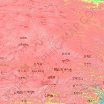
Name: Lhasa topographic map, elevation, terrain.
Location: Lhasa, Tibet, 850000, China (29.24065 89.75281 31.05753 92.62453)
Average elevation: 4,825 m
Minimum elevation: 3,538 m
Maximum elevation: 7,025 m
Other topographic maps
Click on a map to view its topography, its elevation and its terrain.
Shigatse
China > Tibet > Chengdong Subdistrict
Shigatse Peace Airport began operations on 30 October 2010 after an Airbus A319 landed safely, making it Tibet's fifth commercial airport. It is located 43 kilometres from Samzhubzê District at Jangdam Township at an elevation of 3,782 metres. The airport will be capable of supporting 230,000 passengers…
Average elevation: 4,055 m