
Ocean County topographic map
Interactive map
Click on the map to display elevation.
About this map
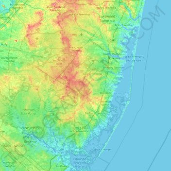
Name: Ocean County topographic map, elevation, terrain.
Location: Ocean County, New Jersey, United States of America (39.47520 -74.55311 40.17236 -73.96611)
Average elevation: 15 m
Minimum elevation: -2 m
Maximum elevation: 78 m
Much of the county is flat and coastal, with many beaches. The highest point is one of three unnamed hills (one in Jackson Township, the other two in Plumsted Township) that reach at least 230 feet (70 m) in elevation. The lowest elevation in the county is sea level.
Other topographic maps
Click on a map to view its topography, its elevation and its terrain.
Crossroads
United States of America > New Jersey > Crossroads
Crossroads, Medford Township, Burlington County, New Jersey, 08053-5616, United States of America
Average elevation: 17 m
Green Knoll
United States of America > New Jersey > Bridgewater Township > Green Knoll
Green Knoll, Bridgewater Township, Somerset County, New Jersey, 08807, United States of America
Average elevation: 63 m