
Make a donation
Gear up for your next adventure:
As an Amazon Associate, this site earns from qualifying purchases at no extra cost to you.
Odesa topographic map
Click on the map to display elevation.
Make a donation
Gear up for your next adventure:
As an Amazon Associate, this site earns from qualifying purchases at no extra cost to you.
Odesa
The city is situated on terraced hills overlooking a small harbor. The average elevation at which the city is located is around 50 metres (160 feet). The maximum is 65 metres (213 feet) and minimum (on the coast) amounts to 4.2 metres (13.8 feet) above sea level. There are three large estuaries near the city: Kuialnyk, Khadzhibey and Sukhyi.
Make a donation
Gear up for your next adventure:
As an Amazon Associate, this site earns from qualifying purchases at no extra cost to you.
About this map
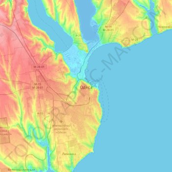
Name: Odesa topographic map, elevation, terrain.
Location: Odesa, Odesa Urban Hromada, Odesa Raion, Odesa Oblast, Ukraine (46.34267 30.61140 46.62912 30.83138)
Average elevation: 26 m
Minimum elevation: -8 m
Maximum elevation: 83 m
Make a donation
Gear up for your next adventure:
As an Amazon Associate, this site earns from qualifying purchases at no extra cost to you.