
Madison County topographic map
Interactive map
Click on the map to display elevation.
About this map
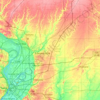
Name: Madison County topographic map, elevation, terrain.
Location: Madison County, Illinois, USA (38.65590 -90.27581 39.00022 -89.59673)
Average elevation: 161 m
Minimum elevation: 119 m
Maximum elevation: 212 m
Other topographic maps
Click on a map to view its topography, its elevation and its terrain.
Montague Island
Montague Island, Rockford, Winnebago County, Illinois, 61104, USA
Average elevation: 254 m
Mount Carmel
USA > Illinois > Mount Carmel
Mount Carmel, Wabash County, Illinois, USA
Average elevation: 128 m
Garfield Ridge
Garfield Ridge, Chicago, Cook County, Illinois, USA
Average elevation: 184 m