
Make a donation
Gear up for your next adventure:
As an Amazon Associate, this site earns from qualifying purchases at no extra cost to you.
Harpers Ferry topographic map
Click on the map to display elevation.
Make a donation
Gear up for your next adventure:
As an Amazon Associate, this site earns from qualifying purchases at no extra cost to you.
Harpers Ferry
The town was "easy to seize, and hard to hold", because of its topography: surrounded on three sides by high ground (Bolivar Heights to the west, Loudoun Heights to the south, and Maryland Heights to the east) and the Potomac and Shenandoah Rivers, anyone who controlled the heights controlled the city.
Make a donation
Gear up for your next adventure:
As an Amazon Associate, this site earns from qualifying purchases at no extra cost to you.
About this map
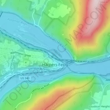
Name: Harpers Ferry topographic map, elevation, terrain.
Average elevation: 174 m
Minimum elevation: 71 m
Maximum elevation: 421 m
Make a donation
Gear up for your next adventure:
As an Amazon Associate, this site earns from qualifying purchases at no extra cost to you.