
Make a donation
Gear up for your next adventure:
As an Amazon Associate, this site earns from qualifying purchases at no extra cost to you.
La Cañada Flintridge topographic map
Click on the map to display elevation.
Make a donation
Gear up for your next adventure:
As an Amazon Associate, this site earns from qualifying purchases at no extra cost to you.
La Cañada Flintridge
La Cañada Flintridge varies in elevation from about 970 feet (300 m) just below Devil's Gate Dam in the Arroyo Seco to about 2,400 feet (730 m) at the highest neighborhood, along the mountain front east of Pickens Canyon, at the upper end of Ocean View Blvd. The city limits extend into the San Gabriel Mountains and reach 3,440 feet (1,050 m) along Mount Lukens Road, which follows the crest line well above the developed city.
Make a donation
Gear up for your next adventure:
As an Amazon Associate, this site earns from qualifying purchases at no extra cost to you.
About this map
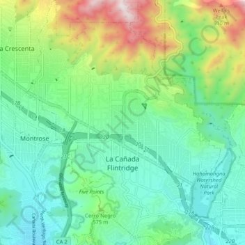
Name: La Cañada Flintridge topographic map, elevation, terrain.
Average elevation: 503 m
Minimum elevation: 265 m
Maximum elevation: 1,133 m
Make a donation
Gear up for your next adventure:
As an Amazon Associate, this site earns from qualifying purchases at no extra cost to you.