
Boston topographic map
Interactive map
Click on the map to display elevation.
About this map
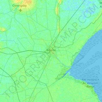
Name: Boston topographic map, elevation, terrain.
Location: Boston, Lincolnshire, England, United Kingdom (52.86280 -0.24671 53.08666 0.23855)
Average elevation: 3 m
Minimum elevation: -2 m
Maximum elevation: 14 m
Other topographic maps
Click on a map to view its topography, its elevation and its terrain.
Spalding
United Kingdom > England > Lincolnshire > South Holland
Spalding, South Holland, Lincolnshire, England, PE11 1SR, United Kingdom
Average elevation: 4 m
Market Rasen TC
United Kingdom > England > Lincolnshire > West Lindsey
Market Rasen TC, West Lindsey, Lincolnshire, England, United Kingdom
Average elevation: 30 m