Geolocate

Newick topographic map

Click on the map to display elevation.

About this map

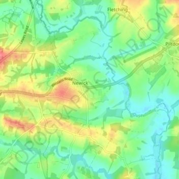
Name: Newick topographic map, elevation, terrain.

Location: Newick, Lewes, East Sussex, England, United Kingdom (50.95029 -0.00297 50.99501 0.05442)

Average elevation: 32 m

Minimum elevation: 9 m

Maximum elevation: 73 m

Gear up for your next adventure:

🚨Emergency Whistles - Safety whistles for hikers
🧊Winter Boot Traction - Grip for icy paths in the Mourne or Derryveagh mountains
👖Zip-off Hiking Pants - Adapt to changing Irish temperatures quickly
🎁Outdoor Gift Ideas - Great gifts for adventurers
🎒Technical Hiking Daypacks - Ergonomic backpacks with hydration bladder compatibility

As an Amazon Associate, this site earns from qualifying purchases at no extra cost to you.