
Make a donation
Gear up for your next adventure:
As an Amazon Associate, this site earns from qualifying purchases at no extra cost to you.
Mount Cameroon topographic map
Click on the map to display elevation.
Make a donation
Gear up for your next adventure:
As an Amazon Associate, this site earns from qualifying purchases at no extra cost to you.
Mount Cameroon
Mount Cameroon is an active volcano in the South West region of Cameroon next to the city of Buea near the Gulf of Guinea. Mount Cameroon is also known as Cameroon Mountain or Fako (the name of the higher of its two peaks) or by its indigenous name Mongo ma Ndemi ("Mountain of Greatness"). Mount Cameroon is ranked 22nd by topographic isolation.
Make a donation
Gear up for your next adventure:
As an Amazon Associate, this site earns from qualifying purchases at no extra cost to you.
About this map
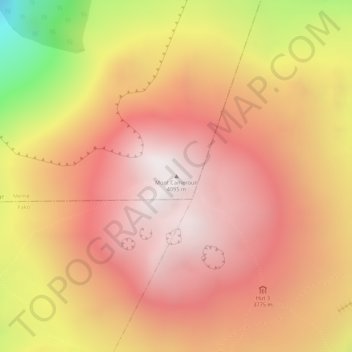
Name: Mount Cameroon topographic map, elevation, terrain.
Location: Mount Cameroon, Mbonge, Meme, Southwest, Cameroon (4.21798 9.17331 4.21808 9.17341)
Average elevation: 3,645 m
Minimum elevation: 2,843 m
Maximum elevation: 4,020 m
Make a donation
Gear up for your next adventure:
As an Amazon Associate, this site earns from qualifying purchases at no extra cost to you.