
Make a donation
Gear up for your next adventure:
As an Amazon Associate, this site earns from qualifying purchases at no extra cost to you.
Kinmen topographic map
Click on the map to display elevation.
Gear up for your next adventure:
As an Amazon Associate, this site earns from qualifying purchases at no extra cost to you.
About this map
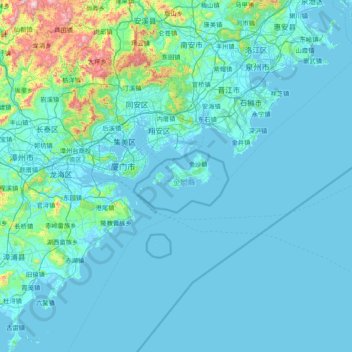
Name: Kinmen topographic map, elevation, terrain.
Location: Kinmen, 89350, Taiwan (23.73676 117.61864 25.13676 119.01864)
Average elevation: 90 m
Minimum elevation: -3 m
Maximum elevation: 1,408 m
Make a donation
Gear up for your next adventure:
As an Amazon Associate, this site earns from qualifying purchases at no extra cost to you.
Other topographic maps
Click on a map to view its topography, its elevation and its terrain.
Yunlin County
Penglai Waterfall is located in Penny's Water Creek Valley on the east side of the Caoling settlement in Gukeng Township. It belongs to the Zhuoshui River Basin. The altitude of the waterfall is about 920 meters, and the drop is about 70 meters. It is listed as one of the ten scenic spots in Caoling.
Average elevation: 391 m
Make a donation
Gear up for your next adventure:
As an Amazon Associate, this site earns from qualifying purchases at no extra cost to you.
Make a donation
Gear up for your next adventure:
As an Amazon Associate, this site earns from qualifying purchases at no extra cost to you.
Make a donation
Gear up for your next adventure:
As an Amazon Associate, this site earns from qualifying purchases at no extra cost to you.
Make a donation
Gear up for your next adventure:
As an Amazon Associate, this site earns from qualifying purchases at no extra cost to you.
Make a donation
Gear up for your next adventure:
As an Amazon Associate, this site earns from qualifying purchases at no extra cost to you.
Make a donation
Gear up for your next adventure:
As an Amazon Associate, this site earns from qualifying purchases at no extra cost to you.
Make a donation
Gear up for your next adventure:
As an Amazon Associate, this site earns from qualifying purchases at no extra cost to you.
Make a donation
Gear up for your next adventure:
As an Amazon Associate, this site earns from qualifying purchases at no extra cost to you.
Make a donation
Gear up for your next adventure:
As an Amazon Associate, this site earns from qualifying purchases at no extra cost to you.
Yangmingshan National Park
Unlike most other national parks, the Yangmingshan National Park has a lower elevation. Although the park's elevation ranges from only 200–1120 meters, beautiful landscapes such as ridges, valleys, lakes, waterfalls, and basins are abundant. Andesite rocks make up most of the area's geology.
Average elevation: 397 m
Alishan Township
It has a population total of 5,374 and an area of 427.8471 square kilometres. It is located at an elevation of 2,190 metres (7,190 ft) in the western highlands of Taiwan.
Average elevation: 1,645 m
Make a donation
Gear up for your next adventure:
As an Amazon Associate, this site earns from qualifying purchases at no extra cost to you.
Make a donation
Gear up for your next adventure:
As an Amazon Associate, this site earns from qualifying purchases at no extra cost to you.
Make a donation
Gear up for your next adventure:
As an Amazon Associate, this site earns from qualifying purchases at no extra cost to you.
Yilan City
Yilan City is located on Lanyang Plain with an average altitude of 7.38 meters above sea level.
Average elevation: 10 m
Make a donation
Gear up for your next adventure:
As an Amazon Associate, this site earns from qualifying purchases at no extra cost to you.
Changhua County
Taiwan > Taiwan Province > Changhua County
The County's total area is 1,074 km2 (415 sq mi), being Taiwan's smallest county. It owns a 60 km (37 mi) of coastline. The landscape of Changhua can be roughly divided into two parts, one being the western flat land, and the other being the Changhua Plain. This two combines together measures up to 88% of…
Average elevation: 75 m
Make a donation
Gear up for your next adventure:
As an Amazon Associate, this site earns from qualifying purchases at no extra cost to you.
Make a donation
Gear up for your next adventure:
As an Amazon Associate, this site earns from qualifying purchases at no extra cost to you.
Make a donation
Gear up for your next adventure:
As an Amazon Associate, this site earns from qualifying purchases at no extra cost to you.