
Make a donation
Gear up for your next adventure:
As an Amazon Associate, this site earns from qualifying purchases at no extra cost to you.
Gemeinde Vandans topographic map
Click on the map to display elevation.
Make a donation
Gear up for your next adventure:
As an Amazon Associate, this site earns from qualifying purchases at no extra cost to you.
About this map
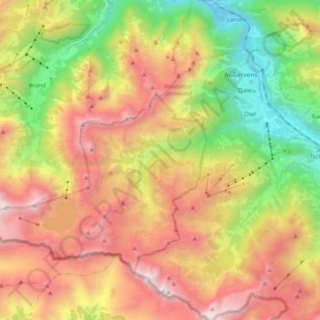
Name: Gemeinde Vandans topographic map, elevation, terrain.
Location: Gemeinde Vandans, Bezirk Bludenz, Vorarlberg, 6773, Austria (47.03125 9.70567 47.11865 9.88795)
Average elevation: 1,646 m
Minimum elevation: 576 m
Maximum elevation: 2,810 m
Make a donation
Gear up for your next adventure:
As an Amazon Associate, this site earns from qualifying purchases at no extra cost to you.
Other topographic maps
Click on a map to view its topography, its elevation and its terrain.
Montafon
Austria > Vorarlberg > Bezirk Bludenz > Gemeinde Sankt Gallenkirch
Tourism plays a vital role and the Montafon is well-known for its skiing, hiking, and mountain biking. The Silvretta high alpine road (German: Hochalpenstraße) gives access to remote ski areas that are located altitudes of 650 to 1,430 meters. The construction of the Montafon Railway in 1905 also helped…
Average elevation: 1,566 m