
Make a donation
Gear up for your next adventure:
As an Amazon Associate, this site earns from qualifying purchases at no extra cost to you.
Althütte topographic map
Click on the map to display elevation.
Make a donation
Gear up for your next adventure:
As an Amazon Associate, this site earns from qualifying purchases at no extra cost to you.
Althütte
The municipality (Gemeinde) of Althütte is located in the Rems-Murr district, in the German state of Baden-Württemberg. Althütte is physically located in the Murrhardt Forest, a region of the larger Swabian-Franconian Forest. Elevation above sea level in the municipal area ranges from a high of 571 meters (1,873 ft) Normalnull (NN) to a low of 339 meters (1,112 ft) NN.
Make a donation
Gear up for your next adventure:
As an Amazon Associate, this site earns from qualifying purchases at no extra cost to you.
About this map
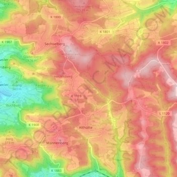
Name: Althütte topographic map, elevation, terrain.
Average elevation: 464 m
Minimum elevation: 289 m
Maximum elevation: 571 m
Make a donation
Gear up for your next adventure:
As an Amazon Associate, this site earns from qualifying purchases at no extra cost to you.
Other topographic maps
Click on a map to view its topography, its elevation and its terrain.
Kleinhegnach
Germany > Baden-Württemberg > Rems-Murr-Kreis > Waiblingen > Neustadt
Average elevation: 277 m