
Thank you for supporting this site ❤️
Make a donation
Make a donation
Gear up for your next adventure:
As an Amazon Associate, this site earns from qualifying purchases at no extra cost to you.
Llanidloes topographic map
Click on the map to display elevation.
Thank you for supporting this site ❤️
Make a donation
Make a donation
Gear up for your next adventure:
As an Amazon Associate, this site earns from qualifying purchases at no extra cost to you.
About this map
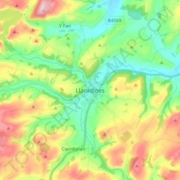
Name: Llanidloes topographic map, elevation, terrain.
Location: Llanidloes, Powys, Wales, SY18 6BH, United Kingdom (52.40824 -3.58109 52.48824 -3.50109)
Average elevation: 267 m
Minimum elevation: 140 m
Maximum elevation: 480 m
Thank you for supporting this site ❤️
Make a donation
Make a donation
Gear up for your next adventure:
As an Amazon Associate, this site earns from qualifying purchases at no extra cost to you.