
Houston topographic map
Interactive map
Click on the map to display elevation.
About this map
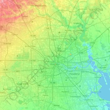
Name: Houston topographic map, elevation, terrain.
Location: Houston, Harris County, Texas, United States (29.53707 -95.90974 30.11035 -95.01205)
Average elevation: 25 m
Minimum elevation: -3 m
Maximum elevation: 98 m
Much of the city was built on forested land, marshes, or swamps, and all are still visible in surrounding areas. Flat terrain and extensive greenfield development have combined to worsen flooding. Downtown stands about 50 feet (15 m) above sea level, and the highest point in far northwest Houston is about 150 feet (46 m) in elevation. The city once relied on groundwater for its needs, but land subsidence forced the city to turn to ground-level water sources such as Lake Houston, Lake Conroe, and Lake Livingston. The city owns surface water rights for 1.20 billion US gallons (4.5 Gl) of water a day in addition to 150 million US gallons (570 Ml) a day of groundwater.
Other topographic maps
Click on a map to view its topography, its elevation and its terrain.
Memorial Park
United States > Texas > Harris County > Houston
Memorial Park, Houston, Harris County, Texas, 77007, United States
Average elevation: 21 m
Sylvester Turner Park
United States > Texas > Harris County > Houston
Sylvester Turner Park, Houston, Harris County, Texas, United States
Average elevation: 27 m