
Make a donation
Gear up for your next adventure:
As an Amazon Associate, this site earns from qualifying purchases at no extra cost to you.
Pittsfield topographic map
Click on the map to display elevation.
Make a donation
Gear up for your next adventure:
As an Amazon Associate, this site earns from qualifying purchases at no extra cost to you.
Pittsfield
Pittsfield has a humid continental climate (Dfb). Winters are harsh due the city's high elevation at 1,039 ft (317 m), with an average annual snowfall of 75.9 inches (1,930 mm) and temperatures dipping to 0 °F (−18 °C) or colder 13 times per year. Summers, however, are typically warm and pleasant, with temperatures reaching 90 °F (32 °C) just six times per year. The record high and record low are 101 °F (38 °C) and −26 °F (−32 °C), recorded on July 23, 1926, and February 15, 1943, respectively. Over the course of a year, 173 days have measurable precipitation.
Make a donation
Gear up for your next adventure:
As an Amazon Associate, this site earns from qualifying purchases at no extra cost to you.
About this map
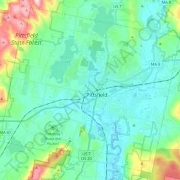
Name: Pittsfield topographic map, elevation, terrain.
Location: Pittsfield, Berkshire County, Massachusetts, United States (42.39813 -73.33891 42.50461 -73.18220)
Average elevation: 369 m
Minimum elevation: 286 m
Maximum elevation: 697 m
Make a donation
Gear up for your next adventure:
As an Amazon Associate, this site earns from qualifying purchases at no extra cost to you.