
Make a donation
Gear up for your next adventure:
As an Amazon Associate, this site earns from qualifying purchases at no extra cost to you.
South Jordan topographic map
Click on the map to display elevation.
Make a donation
Gear up for your next adventure:
As an Amazon Associate, this site earns from qualifying purchases at no extra cost to you.
South Jordan
The relative flatness of South Jordan is due to lacustrine sediments of a pleistocene lake called Lake Bonneville. Lake Bonneville existed from 75,000 to 8,000 years ago; at its peak some 30,000 years ago, the lake reached an elevation of 5,200 feet (1,600 m) above sea level and had a surface area of 19,800 square miles (51,000 km2). The elevation of South Jordan ranges from approximately 4,300 feet (1,300 m) near the Jordan River in the east and rises gently to the foothills of the Oquirrh Mountains at 5,200 feet (1,600 m).
Make a donation
Gear up for your next adventure:
As an Amazon Associate, this site earns from qualifying purchases at no extra cost to you.
About this map
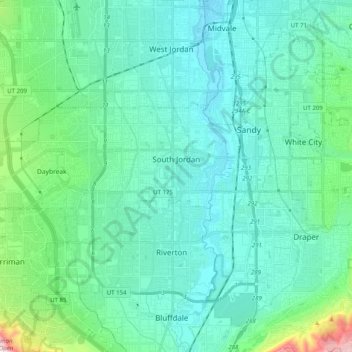
Name: South Jordan topographic map, elevation, terrain.
Location: South Jordan, Salt Lake County, Utah, 84095, United States (40.51957 -112.09472 40.58212 -111.89457)
Average elevation: 1,407 m
Minimum elevation: 1,304 m
Maximum elevation: 1,970 m
Make a donation
Gear up for your next adventure:
As an Amazon Associate, this site earns from qualifying purchases at no extra cost to you.
Other topographic maps
Click on a map to view its topography, its elevation and its terrain.
South Valence Drainage
United States > Utah > Salt Lake County > West Jordan
Average elevation: 1,388 m