Geolocate

Hassocks topographic map

Click on the map to display elevation.

About this map

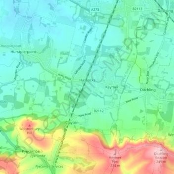
Name: Hassocks topographic map, elevation, terrain.

Location: Hassocks, Mid Sussex, West Sussex, England, United Kingdom (50.89388 -0.16206 50.95003 -0.11690)

Average elevation: 80 m

Minimum elevation: 20 m

Maximum elevation: 252 m

Gear up for your next adventure:

💨Windbreakers - Protection from strong winds
🚨High-Decibel Whistles - Standard safety gear for mountain signaling
🕶️Polarized Sunglasses - Reduce glare outdoors
🎽Thermal Base Layers - Essential moisture management for cold weather
🚲Cycling GPS Computers - Topographic mapping for Irish road and mountain biking

As an Amazon Associate, this site earns from qualifying purchases at no extra cost to you.