
Make a donation
Gear up for your next adventure:
As an Amazon Associate, this site earns from qualifying purchases at no extra cost to you.
Suzhou City topographic map
Click on the map to display elevation.
Make a donation
Gear up for your next adventure:
As an Amazon Associate, this site earns from qualifying purchases at no extra cost to you.
Suzhou City
The landform is characterized by gentle plains. Suzhou's terrain is uniformly low-lying, sloping gradually from west to east. The elevation of its plains ranges between 3–4 meters, while areas around Yangcheng Lake and Wujiang drop to approximately 2 meters.
Make a donation
Gear up for your next adventure:
As an Amazon Associate, this site earns from qualifying purchases at no extra cost to you.
About this map
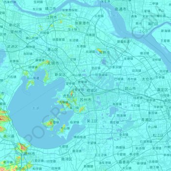
Name: Suzhou City topographic map, elevation, terrain.
Location: Suzhou City, Jiangsu, China (30.76033 119.91621 32.04578 121.38294)
Average elevation: 6 m
Minimum elevation: -4 m
Maximum elevation: 466 m
Make a donation
Gear up for your next adventure:
As an Amazon Associate, this site earns from qualifying purchases at no extra cost to you.
Other topographic maps
Click on a map to view its topography, its elevation and its terrain.
Make a donation
Gear up for your next adventure:
As an Amazon Associate, this site earns from qualifying purchases at no extra cost to you.
Make a donation
Gear up for your next adventure:
As an Amazon Associate, this site earns from qualifying purchases at no extra cost to you.
Make a donation
Gear up for your next adventure:
As an Amazon Associate, this site earns from qualifying purchases at no extra cost to you.