
Make a donation
Gear up for your next adventure:
As an Amazon Associate, this site earns from qualifying purchases at no extra cost to you.
Lucena topographic map
Click on the map to display elevation.
Make a donation
Gear up for your next adventure:
As an Amazon Associate, this site earns from qualifying purchases at no extra cost to you.
Lucena
Lucena is located in the transition zone between the campiña in the Guadalquivir Depression and the Subbaetic system, at an altitude above mean sea level slightly below 500 meters. The Subbaetic system include neighboring subranges such as the sierras of Cabra, Carcabuey, Pollos, Horconera, and Rute.
Make a donation
Gear up for your next adventure:
As an Amazon Associate, this site earns from qualifying purchases at no extra cost to you.
About this map
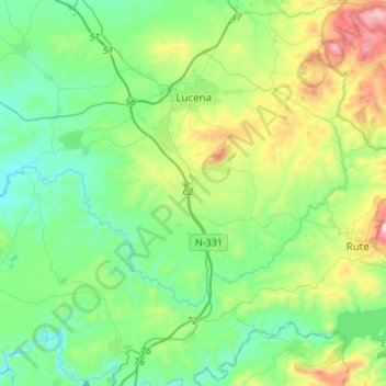
Name: Lucena topographic map, elevation, terrain.
Location: Lucena, Cordova, Andalusia, 14900, Spain (37.24670 -4.68407 37.46382 -4.41701)
Average elevation: 476 m
Minimum elevation: 241 m
Maximum elevation: 1,151 m
Make a donation
Gear up for your next adventure:
As an Amazon Associate, this site earns from qualifying purchases at no extra cost to you.
Other topographic maps
Click on a map to view its topography, its elevation and its terrain.
Make a donation
Gear up for your next adventure:
As an Amazon Associate, this site earns from qualifying purchases at no extra cost to you.