
Make a donation
Gear up for your next adventure:
As an Amazon Associate, this site earns from qualifying purchases at no extra cost to you.
Capitol Reef National Park topographic map
Click on the map to display elevation.
Make a donation
Gear up for your next adventure:
As an Amazon Associate, this site earns from qualifying purchases at no extra cost to you.
About this map
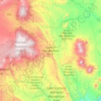
Name: Capitol Reef National Park topographic map, elevation, terrain.
Average elevation: 1,963 m
Minimum elevation: 1,119 m
Maximum elevation: 3,484 m
Make a donation
Gear up for your next adventure:
As an Amazon Associate, this site earns from qualifying purchases at no extra cost to you.
Other topographic maps
Click on a map to view its topography, its elevation and its terrain.
Mammoth Cave
United States > Utah > Garfield County
Mammoth Cave is a lava tube located on the Markagunt Plateau in the Dixie National Forest of Southern Utah, and is one of the largest lava tubes in Utah. The cave has over 2,200 feet (670 m) of passage and is about a quarter mile (400 m) long. It was formed by cooling lava and water less than 2,000 years ago.…
Average elevation: 2,422 m