Geolocate

Oak Ridge topographic map

Click on the map to display elevation.

Oak Ridge

According to the United States Census Bureau, the city has an area of 90.0 square miles (233.0 km2), of which 85.3 square miles (220.8 km2) is land and 4.7 square miles (12.2 km2), or 5.25%, is water. The highest point is Melton Hill (35°54′35″N 84°18′19″W / 35.90962°N 84.30525°W / 35.90962; -84.30525) on the DOE reservation, at elevation 1,356 feet (413 m).

Wikipedia (CC-BY-SA 3.0)

About this map

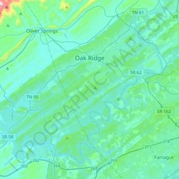
Name: Oak Ridge topographic map, elevation, terrain.

Location: Oak Ridge, Anderson County, East Tennessee, Tennessee, United States (35.87487 -84.43659 36.06450 -84.15656)

Average elevation: 290 m

Minimum elevation: 207 m

Maximum elevation: 940 m

Gear up for your next adventure:

🧶Camping String Lights - Ambience and utility lighting
🥾Lightweight Hiking Shoes - Light, breathable shoes for trail walking
🍖Freeze-Dried Trail Meals - Nutritious and lightweight food for expeditions
🩹Compact First Aid Kits - Treat blisters and minor injuries on the trail
🔨Multi-tool Devices - Versatile tools for gear repairs in the field

As an Amazon Associate, this site earns from qualifying purchases at no extra cost to you.