
Guangzhou City topographic map
Interactive map
Click on the map to display elevation.
About this map
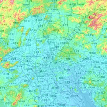
Name: Guangzhou City topographic map, elevation, terrain.
Location: Guangzhou City, Guangdong Province, China (22.51769 112.95293 23.93608 114.05008)
Average elevation: 98 m
Minimum elevation: -10 m
Maximum elevation: 1,206 m
The elevation of the prefecture generally increases from southwest to northeast, with mountains forming the backbone of the city and the ocean comprising the front. Tiantang Peak (simplified Chinese: 天堂顶; traditional Chinese: 天堂頂, "Heavenly Peak") is the highest point of elevation at 1,210 meters (3,970 ft) above sea level.