
Thank you for supporting this site ❤️
Make a donation
Make a donation
Gear up for your next adventure:
As an Amazon Associate, this site earns from qualifying purchases at no extra cost to you.
Bastheim topographic map
Click on the map to display elevation.
Thank you for supporting this site ❤️
Make a donation
Make a donation
Gear up for your next adventure:
As an Amazon Associate, this site earns from qualifying purchases at no extra cost to you.
About this map
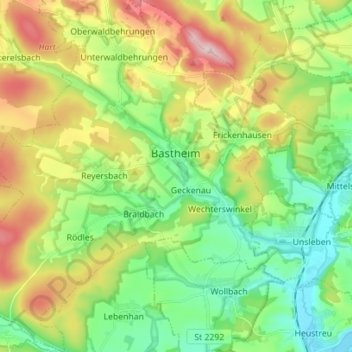
Name: Bastheim topographic map, elevation, terrain.
Location: Bastheim, Landkreis Rhön-Grabfeld, Bavaria, 97654, Germany (50.35026 10.11653 50.43944 10.23909)
Average elevation: 337 m
Minimum elevation: 232 m
Maximum elevation: 519 m
Thank you for supporting this site ❤️
Make a donation
Make a donation
Gear up for your next adventure:
As an Amazon Associate, this site earns from qualifying purchases at no extra cost to you.