
Đakovo topographic map
Interactive map
Click on the map to display elevation.
Đakovo
Đakovo is located 37 km (23 mi) to the southwest of Osijek and 34 km (21 mi) southeast of Našice; elevation 111 m. It is located near the A5 motorway, at the intersection of the D7 state road to Osijek, the arterial roads D38 to Požega, D46 to Vinkovci and the connecting road D515 to Našice.
About this map
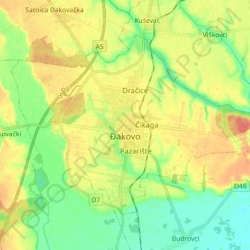
Name: Đakovo topographic map, elevation, terrain.
Location: Đakovo, Grad Đakovo, Osijek-Baranja County, 31400, Croatia (45.27974 18.35328 45.34470 18.48112)
Average elevation: 103 m
Minimum elevation: 80 m
Maximum elevation: 130 m
Other topographic maps
Click on a map to view its topography, its elevation and its terrain.