
Thank you for supporting this site ❤️
Make a donation
Make a donation
Gear up for your next adventure:
As an Amazon Associate, this site earns from qualifying purchases at no extra cost to you.
Taquile topographic map
Click on the map to display elevation.
Thank you for supporting this site ❤️
Make a donation
Make a donation
Gear up for your next adventure:
As an Amazon Associate, this site earns from qualifying purchases at no extra cost to you.
About this map
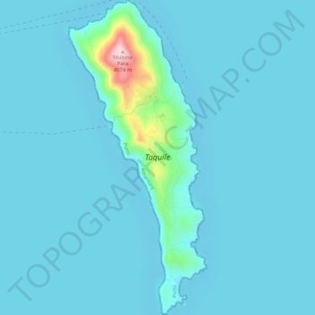
Name: Taquile topographic map, elevation, terrain.
Location: Taquile, Amantaní, Province of Puno, Puno, Peru (-15.79880 -69.69829 -15.74964 -69.67584)
Average elevation: 3,829 m
Minimum elevation: 3,808 m
Maximum elevation: 4,071 m
Thank you for supporting this site ❤️
Make a donation
Make a donation
Gear up for your next adventure:
As an Amazon Associate, this site earns from qualifying purchases at no extra cost to you.