
Šipovo topographic map
Interactive map
Click on the map to display elevation.
Šipovo
In the geomorphologic sense, Šipovo is a mountain region whose average height is 800 metres above sea level. In the global climatic sense, Šipovo lies in temperately continental zone, with certain differences the reason for which being variations in height above sea level, as well as topographic and vegetational elements. The air temperature is the basic climatic element. The average annual temperature is 10˚C, the average summer temperature is 20˚C, and the average winter temperature is around 0˚C. The average annual insolation is 1800 hours, which makes five hours per day. The average annual humidity is around 85%. Precipitations are very important climatic element. The average value of annual precipitations is 990 mm. The average number of snowy days is 120, whereas the vegetational period lasts for about 250 days. There are a lot of foggy days in Šipovo. Winds are very often in the southern part of the area (Janjska visoravan) due to intermixing of the Mediterranean and continental air masses over Janj.
About this map
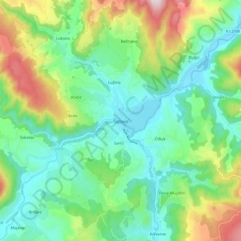
Name: Šipovo topographic map, elevation, terrain.
Average elevation: 612 m
Minimum elevation: 430 m
Maximum elevation: 1,039 m
Other topographic maps
Click on a map to view its topography, its elevation and its terrain.
Jahorina
Bosnia and Herzegovina > Republika Srpska > City of Istočno Sarajevo
Jahorina (Serbian Cyrillic: Јахорина, pronounced [jâxɔrina]) is a mountain in Bosnia and Herzegovina, located at the tripoint of the municipalities of Pale, Trnovo, Republika Srpska and Trnovo, Federation of Bosnia and Herzegovina. Part of the Dinaric Alps, it borders Mount Trebević. Its highest…
Average elevation: 1,131 m
Prijedor
Bosnia and Herzegovina > Republika Srpska > City of Prijedor
The urban centre of Prijedor, within the city of Prijedor, is located in the northwestern part of Bosnia and Herzegovina, on the banks of the Sana and Gomjenica rivers, and at the southwestern hills of the Kozara mountain. The area of the municipality is 833 square kilometres (322 square miles). The town is…
Average elevation: 147 m
Jahorina
Bosnia and Herzegovina > Republika Srpska > City of Istočno Sarajevo
Jahorina (Serbian Cyrillic: Јахорина, pronounced [jâxɔrina]) is a mountain in Bosnia and Herzegovina, located at the tripoint of the municipalities of Pale, Trnovo, Republika Srpska and Trnovo, Federation of Bosnia and Herzegovina. Part of the Dinaric Alps, it borders Mount Trebević. Its highest…
Average elevation: 1,131 m
Strict Nature Reserve Primeval Forest Janj
Bosnia and Herzegovina > Republika Srpska
Average elevation: 1,170 m
Prijedor
Bosnia and Herzegovina > Republika Srpska > City of Prijedor
The urban centre of Prijedor, within the city of Prijedor, is located in the northwestern part of Bosnia and Herzegovina, on the banks of the Sana and Gomjenica rivers, and at the southwestern hills of the Kozara mountain. The area of the municipality is 833 square kilometres (322 square miles). The town is…
Average elevation: 147 m