
Make a donation
Gear up for your next adventure:
As an Amazon Associate, this site earns from qualifying purchases at no extra cost to you.
Huntingdon County topographic map
Click on the map to display elevation.
Make a donation
Gear up for your next adventure:
As an Amazon Associate, this site earns from qualifying purchases at no extra cost to you.
About this map
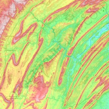
Name: Huntingdon County topographic map, elevation, terrain.
Location: Huntingdon County, Pennsylvania, United States (40.06142 -78.25731 40.74345 -77.67660)
Average elevation: 380 m
Minimum elevation: 140 m
Maximum elevation: 798 m
Make a donation
Gear up for your next adventure:
As an Amazon Associate, this site earns from qualifying purchases at no extra cost to you.
Other topographic maps
Click on a map to view its topography, its elevation and its terrain.
Woodcock Hill
United States > Pennsylvania > Fayette County > Henry Clay Township
Average elevation: 686 m
Holiday Poconos
United States > Pennsylvania > Carbon County > Kidder Township
Average elevation: 519 m
West Pittsburg
United States > Pennsylvania > Lawrence County > Taylor Township
Average elevation: 279 m
Make a donation
Gear up for your next adventure:
As an Amazon Associate, this site earns from qualifying purchases at no extra cost to you.
Bird in Hand
United States > Pennsylvania > Lancaster County > East Lampeter Township
Average elevation: 111 m
Intercourse
United States > Pennsylvania > Lancaster County > Leacock Township
Average elevation: 127 m
Skunk Pond (Elevation 1100 feet)
United States > Pennsylvania > Westmoreland County > Murrysville
Average elevation: 323 m
Make a donation
Gear up for your next adventure:
As an Amazon Associate, this site earns from qualifying purchases at no extra cost to you.