
Thank you for supporting this site ❤️
Make a donation
Make a donation
Gear up for your next adventure:
As an Amazon Associate, this site earns from qualifying purchases at no extra cost to you.
Michelstadt topographic map
Click on the map to display elevation.
Thank you for supporting this site ❤️
Make a donation
Make a donation
Gear up for your next adventure:
As an Amazon Associate, this site earns from qualifying purchases at no extra cost to you.
About this map
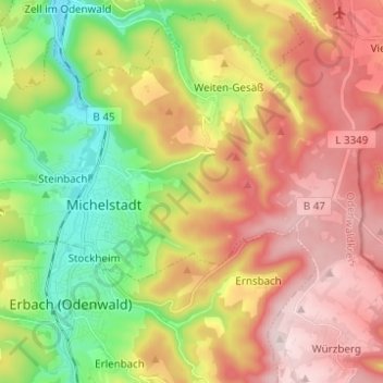
Name: Michelstadt topographic map, elevation, terrain.
Location: Michelstadt, Odenwaldkreis, Hesse, 64720, Germany (49.66571 8.94976 49.69847 9.07306)
Average elevation: 362 m
Minimum elevation: 183 m
Maximum elevation: 548 m
Thank you for supporting this site ❤️
Make a donation
Make a donation
Gear up for your next adventure:
As an Amazon Associate, this site earns from qualifying purchases at no extra cost to you.