
Make a donation
Gear up for your next adventure:
As an Amazon Associate, this site earns from qualifying purchases at no extra cost to you.
Pinal de Amoles topographic map
Click on the map to display elevation.
Make a donation
Gear up for your next adventure:
As an Amazon Associate, this site earns from qualifying purchases at no extra cost to you.
Pinal de Amoles
The Puerta del Cielo (Door of Heaven) is an area just off Highway 120. The area is in forests of pine, cedar and white cedar. In the upper part, there is a chapel to the Virgin Mary with the inscription of “Virgen María Puerta del Cielo” (Virgin Mary Door of Heaven), from which the name is derived. This part of the highway has the highest altitude in Querétaro.
Make a donation
Gear up for your next adventure:
As an Amazon Associate, this site earns from qualifying purchases at no extra cost to you.
About this map
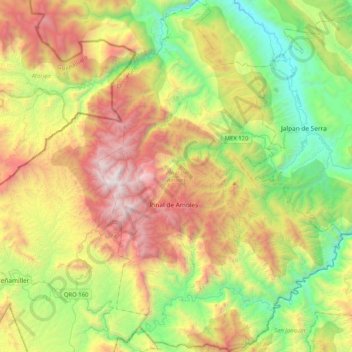
Name: Pinal de Amoles topographic map, elevation, terrain.
Location: Pinal de Amoles, Querétaro, Mexico (20.97489 -99.71585 21.35811 -99.42919)
Average elevation: 1,606 m
Minimum elevation: 624 m
Maximum elevation: 3,143 m
Make a donation
Gear up for your next adventure:
As an Amazon Associate, this site earns from qualifying purchases at no extra cost to you.
Other topographic maps
Click on a map to view its topography, its elevation and its terrain.