Geolocate

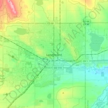
Longmont topographic map

Click on the map to display elevation.

Longmont

The elevation at City Hall is 4,978 feet (1,517 m) above sea level. St. Vrain Creek, a tributary of the South Platte River, flows through the city just south of the city center.

Wikipedia (CC-BY-SA 3.0)

About this map

Name: Longmont topographic map, elevation, terrain.

Location: Longmont, Boulder County, Colorado, 80501, United States (40.12639 -105.17838 40.20996 -105.01732)

Average elevation: 1,534 m

Minimum elevation: 1,483 m

Maximum elevation: 1,649 m

Other topographic maps

Click on a map to view its topography, its elevation and its terrain.
Superior

United States > Colorado > Boulder County

Average elevation: 1,689 m

Gear up for your next adventure:

🚶‍♂️Trekking Poles - Supportive poles for stability on varied terrain
🔦High-Lumen Headlamps - Hands-free lighting for early starts or late finishes
🧢Hiking Hats & Caps - Protective headwear for sun and rain
🌂Windproof Trekking Umbrellas - Protection during vertical Irish rain
🧯Compact Fire Extinguishers - Safety for campervans and expedition vehicles

As an Amazon Associate, this site earns from qualifying purchases at no extra cost to you.