
Thank you for supporting this site ❤️
Make a donation
Make a donation
Gear up for your next adventure:
As an Amazon Associate, this site earns from qualifying purchases at no extra cost to you.
Chelyabinsk topographic map
Click on the map to display elevation.
Thank you for supporting this site ❤️
Make a donation
Make a donation
Gear up for your next adventure:
As an Amazon Associate, this site earns from qualifying purchases at no extra cost to you.
Chelyabinsk
Shortly after dawn on February 15, 2013, a superbolide meteor descended at over 55,000 kilometers per hour (34,000 mph) over the Ural Mountains, exploding at an altitude of 25–30 kilometers (16–19 mi).
Thank you for supporting this site ❤️
Make a donation
Make a donation
Gear up for your next adventure:
As an Amazon Associate, this site earns from qualifying purchases at no extra cost to you.
About this map
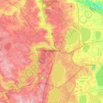
Name: Chelyabinsk topographic map, elevation, terrain.
Average elevation: 230 m
Minimum elevation: 147 m
Maximum elevation: 297 m
Thank you for supporting this site ❤️
Make a donation
Make a donation
Gear up for your next adventure:
As an Amazon Associate, this site earns from qualifying purchases at no extra cost to you.