
Make a donation
Gear up for your next adventure:
As an Amazon Associate, this site earns from qualifying purchases at no extra cost to you.
Mymensingh topographic map
Click on the map to display elevation.
Make a donation
Gear up for your next adventure:
As an Amazon Associate, this site earns from qualifying purchases at no extra cost to you.
Mymensingh
Mymensingh is the 8th administrative divisional headquarter and 12th city corporation of Bangladesh. According to Ministry of Public Administration, Mymensingh is ranked 4th in district status. The density of Mymensingh city is 44,458/km2 (115,150/sq mi) which is the second most densely populated city in Bangladesh. Mymensingh attracts 25 percent of health tourists visiting Bangladesh. Mymensingh is the anglicized pronunciation of the original name Momen Singh, referring to a Muslim ruler called Shah Momin or Momin Singh, an ethnic Bengali Muslim ruler. Its elevation is over 19 m above sea level, the highest of Bangladesh's major cities. Mymensingh related with old Brahmaputra river, handcrafted duvet called Nakshikantha (Bengali: নকশীকাঁথা) and a rural ballad called Maimansingha Gitika. Mymensingh is close to Tura, the second largest city in Meghalaya, and about 63 km from the Gobrakura Land Port.
Make a donation
Gear up for your next adventure:
As an Amazon Associate, this site earns from qualifying purchases at no extra cost to you.
About this map
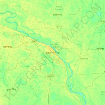
Name: Mymensingh topographic map, elevation, terrain.
Average elevation: 14 m
Minimum elevation: 5 m
Maximum elevation: 22 m
Make a donation
Gear up for your next adventure:
As an Amazon Associate, this site earns from qualifying purchases at no extra cost to you.