
Make a donation
Gear up for your next adventure:
As an Amazon Associate, this site earns from qualifying purchases at no extra cost to you.
Aizawl topographic map
Click on the map to display elevation.
Make a donation
Gear up for your next adventure:
As an Amazon Associate, this site earns from qualifying purchases at no extra cost to you.
Aizawl
Aizawl (English: /aɪˈzɔːl/; Mizo: [ˈaɪ̯.ˈzɔːl] ), formerly known as Aijal, is the capital city and the most populous city of Mizoram, India. It is also the third largest city in northeast India, after Guwahati and Agartala. It is situated atop a series of ridges, with an average elevation of around 1,132 metres (3,714 feet) above sea level. In 2024, the city has an estimated population of 405,000 people.
Make a donation
Gear up for your next adventure:
As an Amazon Associate, this site earns from qualifying purchases at no extra cost to you.
About this map
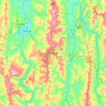
Name: Aizawl topographic map, elevation, terrain.
Location: Aizawl, Tlangnuam, Aizawl, Mizoram, 796190, India (23.56776 92.55799 23.88776 92.87799)
Average elevation: 562 m
Minimum elevation: 61 m
Maximum elevation: 1,515 m
Make a donation
Gear up for your next adventure:
As an Amazon Associate, this site earns from qualifying purchases at no extra cost to you.