
Gresham topographic map
Click on the map to display elevation.
Gresham
Though much of Gresham is relatively flat, it is characterized by a hill on its eastern border. Northeast Gresham is also hilly, particularly where the city meets Troutdale toward the Columbia River. Its elevation is 325 feet (99 m). Johnson Creek, which begins at the foothills of the Cascade Mountains, runs westward through Gresham, with 23 percent of the creek's watershed running through the city.
About this map
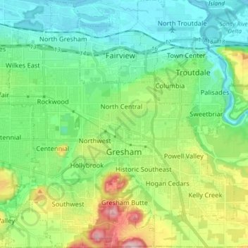
Name: Gresham topographic map, elevation, terrain.
Location: Gresham, Multnomah County, Oregon, United States (45.46094 -122.49807 45.56088 -122.36758)
Average elevation: 90 m
Minimum elevation: -2 m
Maximum elevation: 322 m