Geolocate

Visalia topographic map

Click on the map to display elevation.

About this map

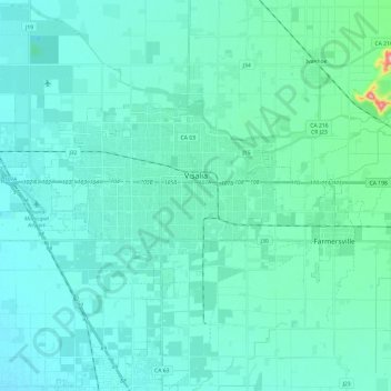
Name: Visalia topographic map, elevation, terrain.

Location: Visalia, Tulare County, California, United States (36.26952 -119.47472 36.37093 -119.23371)

Average elevation: 102 m

Minimum elevation: 82 m

Maximum elevation: 263 m

Other topographic maps

Click on a map to view its topography, its elevation and its terrain.

Bear Mountain

United States > California > Tulare County

Average elevation: 955 m

Moro Rock

United States > California > Tulare County

Average elevation: 1,628 m

Mount Ericsson

United States > California > Tulare County

Average elevation: 3,707 m

Gear up for your next adventure:

🚰Portable Water Filters - Safely drink from Irish streams and mountain lakes
🎒Surveyor High-Vis Vests - Multi-pocket safety vests for field professionals
🦯Lightweight Trekking Poles - Reduce knee strain on steep Wicklow or Kerry slopes
🧯Portable Extinguishers - Safety tools for campfires
🛰️Handheld GPS Units - Professional satellite navigation for Irish highlands

As an Amazon Associate, this site earns from qualifying purchases at no extra cost to you.