
Make a donation
Gear up for your next adventure:
As an Amazon Associate, this site earns from qualifying purchases at no extra cost to you.
Zion topographic map
Click on the map to display elevation.
Make a donation
Gear up for your next adventure:
As an Amazon Associate, this site earns from qualifying purchases at no extra cost to you.
About this map
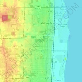
Name: Zion topographic map, elevation, terrain.
Location: Zion, Lake County, Illinois, 60099, United States (42.43068 -87.89814 42.49394 -87.79670)
Average elevation: 198 m
Minimum elevation: 173 m
Maximum elevation: 247 m
Make a donation
Gear up for your next adventure:
As an Amazon Associate, this site earns from qualifying purchases at no extra cost to you.
Other topographic maps
Click on a map to view its topography, its elevation and its terrain.
Make a donation
Gear up for your next adventure:
As an Amazon Associate, this site earns from qualifying purchases at no extra cost to you.
Make a donation
Gear up for your next adventure:
As an Amazon Associate, this site earns from qualifying purchases at no extra cost to you.
Bishops Ridge
United States > Illinois > Lake County > Kildeer > Bishops Ridge
Average elevation: 253 m
Make a donation
Gear up for your next adventure:
As an Amazon Associate, this site earns from qualifying purchases at no extra cost to you.
Lake Naomi
United States > Illinois > Lake County > Hawthorn Woods > White Birch Lakes
Average elevation: 261 m