
Make a donation
Gear up for your next adventure:
As an Amazon Associate, this site earns from qualifying purchases at no extra cost to you.
Morvan topographic map
Click on the map to display elevation.
Make a donation
Gear up for your next adventure:
As an Amazon Associate, this site earns from qualifying purchases at no extra cost to you.
Morvan
It is the smallest mountain area in France in terms of landmass covered, as well as the lowest, with a maximum altitude of 901 metres (2,956 feet) at Haut-Folin.
Make a donation
Gear up for your next adventure:
As an Amazon Associate, this site earns from qualifying purchases at no extra cost to you.
About this map
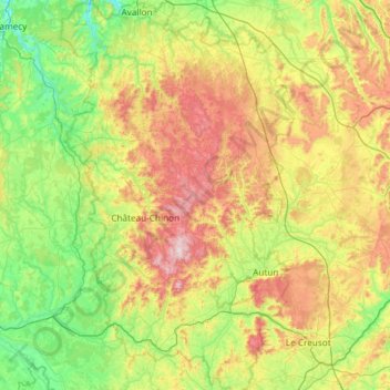
Name: Morvan topographic map, elevation, terrain.
Location: Morvan, Bourgogne – Franche-Comté, Metropolitan France, France (46.70550 3.61107 47.51240 4.54147)
Average elevation: 367 m
Minimum elevation: 139 m
Maximum elevation: 904 m
Make a donation
Gear up for your next adventure:
As an Amazon Associate, this site earns from qualifying purchases at no extra cost to you.
Other topographic maps
Click on a map to view its topography, its elevation and its terrain.
Make a donation
Gear up for your next adventure:
As an Amazon Associate, this site earns from qualifying purchases at no extra cost to you.
Les Loges de Vandenesse
France > Bourgogne – Franche-Comté > Nièvre > Saint-Honoré-les-Bains
Average elevation: 262 m
Make a donation
Gear up for your next adventure:
As an Amazon Associate, this site earns from qualifying purchases at no extra cost to you.
La Croix
France > Bourgogne – Franche-Comté > Saône-et-Loire > Saint-Sernin-du-Bois
Average elevation: 445 m
Make a donation
Gear up for your next adventure:
As an Amazon Associate, this site earns from qualifying purchases at no extra cost to you.
L'Enclose
France > Bourgogne – Franche-Comté > Haute-Saône > Servance-Miellin
Average elevation: 566 m
Make a donation
Gear up for your next adventure:
As an Amazon Associate, this site earns from qualifying purchases at no extra cost to you.
Le Reux
France > Bourgogne – Franche-Comté > Nièvre > Saint-Honoré-les-Bains > Tussy
Average elevation: 354 m
Jardins de l'Hôtel du Département
France > Bourgogne – Franche-Comté > Jura > Lons-le-Saunier
Average elevation: 299 m
Make a donation
Gear up for your next adventure:
As an Amazon Associate, this site earns from qualifying purchases at no extra cost to you.
Dardy
France > Bourgogne – Franche-Comté > Saône-et-Loire > Saint-Pierre-le-Vieux
Average elevation: 486 m
Make a donation
Gear up for your next adventure:
As an Amazon Associate, this site earns from qualifying purchases at no extra cost to you.
Bierre en Morvan
France > Bourgogne – Franche-Comté > Côte-d'Or > La Roche-en-Brenil
Average elevation: 385 m
Make a donation
Gear up for your next adventure:
As an Amazon Associate, this site earns from qualifying purchases at no extra cost to you.
Le Tertre
France > Bourgogne – Franche-Comté > Haute-Saône > Amont-et-Effreney
Average elevation: 504 m
Make a donation
Gear up for your next adventure:
As an Amazon Associate, this site earns from qualifying purchases at no extra cost to you.
Make a donation
Gear up for your next adventure:
As an Amazon Associate, this site earns from qualifying purchases at no extra cost to you.
Verdin
France > Bourgogne – Franche-Comté > Saône-et-Loire > Montagny-près-Louhans
Average elevation: 199 m
Château d'Estours
France > Bourgogne – Franche-Comté > Saône-et-Loire > Crêches-sur-Saône > Estours
Average elevation: 183 m
Make a donation
Gear up for your next adventure:
As an Amazon Associate, this site earns from qualifying purchases at no extra cost to you.
Le Potin
France > Bourgogne – Franche-Comté > Nièvre > Châteauneuf-Val-de-Bargis
Average elevation: 300 m
Saint-Valère
France > Bourgogne – Franche-Comté > Haute-Saône > Port-sur-Saône
Average elevation: 245 m
Make a donation
Gear up for your next adventure:
As an Amazon Associate, this site earns from qualifying purchases at no extra cost to you.
Le Cailleret
France > Bourgogne – Franche-Comté > Côte-d'Or > Puligny-Montrachet
Average elevation: 276 m
Make a donation
Gear up for your next adventure:
As an Amazon Associate, this site earns from qualifying purchases at no extra cost to you.
La Roche d'Amont
France > Bourgogne – Franche-Comté > Haute-Saône > Haut-du-Them
Average elevation: 590 m
Make a donation
Gear up for your next adventure:
As an Amazon Associate, this site earns from qualifying purchases at no extra cost to you.
Les Creux Bréçons
France > Bourgogne – Franche-Comté > Saône-et-Loire > Toulon-sur-Arroux
Average elevation: 284 m
Mont Auxois
France > Bourgogne – Franche-Comté > Côte-d'Or > Alise-Sainte-Reine
Average elevation: 307 m
Make a donation
Gear up for your next adventure:
As an Amazon Associate, this site earns from qualifying purchases at no extra cost to you.
Abbaye en Grandvaux
France > Bourgogne – Franche-Comté > Jura > Grande-Rivière-Château
Average elevation: 956 m
La Vieille Voie
France > Bourgogne – Franche-Comté > Haute-Saône > Corravillers
Average elevation: 593 m
Make a donation
Gear up for your next adventure:
As an Amazon Associate, this site earns from qualifying purchases at no extra cost to you.
Au Faubourg
France > Bourgogne – Franche-Comté > Côte-d'Or > Flavigny-sur-Ozerain
Average elevation: 379 m
La Ferdière du Bas
France > Bourgogne – Franche-Comté > Saône-et-Loire > Navour-sur-Grosne
Average elevation: 363 m
Auvillard
France > Bourgogne – Franche-Comté > Côte-d'Or > Saint-Victor-sur-Ouche
Average elevation: 438 m
Make a donation
Gear up for your next adventure:
As an Amazon Associate, this site earns from qualifying purchases at no extra cost to you.
Les Grandes Vignes
France > Bourgogne – Franche-Comté > Saône-et-Loire > Prissé
Average elevation: 244 m
Make a donation
Gear up for your next adventure:
As an Amazon Associate, this site earns from qualifying purchases at no extra cost to you.