
Make a donation
Gear up for your next adventure:
As an Amazon Associate, this site earns from qualifying purchases at no extra cost to you.
Dundalk topographic map
Click on the map to display elevation.
Make a donation
Gear up for your next adventure:
As an Amazon Associate, this site earns from qualifying purchases at no extra cost to you.
Dundalk
The main part of the census town lies at sea level. Dún Dealgan Motte at Castletown is the highest point in the urban area at an elevation of 60 m (200 ft). The municipal district includes the Cooley Mountains, with Slieve Foy the highest of the peaks at an elevation of 589 m (1,932 ft).
Make a donation
Gear up for your next adventure:
As an Amazon Associate, this site earns from qualifying purchases at no extra cost to you.
About this map
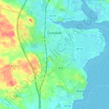
Name: Dundalk topographic map, elevation, terrain.
Location: Dundalk, County Louth, Leinster, Ireland (53.95055 -6.44438 54.02793 -6.34154)
Average elevation: 13 m
Minimum elevation: -1 m
Maximum elevation: 59 m
County Louth trails, hiking, mountain biking, running and outdoor activities
Make a donation
Gear up for your next adventure:
As an Amazon Associate, this site earns from qualifying purchases at no extra cost to you.
Other topographic maps
Click on a map to view its topography, its elevation and its terrain.
Make a donation
Gear up for your next adventure:
As an Amazon Associate, this site earns from qualifying purchases at no extra cost to you.
Make a donation
Gear up for your next adventure:
As an Amazon Associate, this site earns from qualifying purchases at no extra cost to you.