
Lääne maakond topographic map
Interactive map
Click on the map to display elevation.
About this map
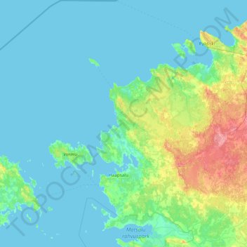
Name: Lääne maakond topographic map, elevation, terrain.
Location: Lääne maakond, Estonia (58.71282 22.73333 59.48333 24.19262)
Average elevation: 8 m
Minimum elevation: -1 m
Maximum elevation: 57 m
Other topographic maps
Click on a map to view its topography, its elevation and its terrain.
Estonia
Estonia lies on the eastern shores of the Baltic Sea immediately across the Gulf of Finland, on the level northwestern part of the rising East European platform between 57.3° and 59.5° N and 21.5° and 28.1° E. Average elevation reaches only 50 metres (164 ft) and the country's highest point is the Suur…
Average elevation: 142 m