
Thank you for supporting this site ❤️
Make a donation
Make a donation
Gear up for your next adventure:
As an Amazon Associate, this site earns from qualifying purchases at no extra cost to you.
Hemyock topographic map
Click on the map to display elevation.
Thank you for supporting this site ❤️
Make a donation
Make a donation
Gear up for your next adventure:
As an Amazon Associate, this site earns from qualifying purchases at no extra cost to you.
About this map
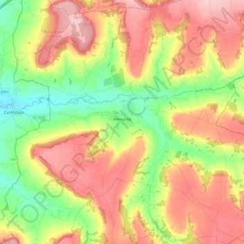
Name: Hemyock topographic map, elevation, terrain.
Location: Hemyock, Devon, England, United Kingdom (50.87644 -3.26542 50.94605 -3.17906)
Average elevation: 192 m
Minimum elevation: 96 m
Maximum elevation: 276 m
Thank you for supporting this site ❤️
Make a donation
Make a donation
Gear up for your next adventure:
As an Amazon Associate, this site earns from qualifying purchases at no extra cost to you.
Other topographic maps
Click on a map to view its topography, its elevation and its terrain.
Bigadon
United Kingdom > England > Devon > Teignbridge > Buckfastleigh > Bigadon
Average elevation: 94 m