
Make a donation
Gear up for your next adventure:
As an Amazon Associate, this site earns from qualifying purchases at no extra cost to you.
Bloemfontein topographic map
Click on the map to display elevation.
Make a donation
Gear up for your next adventure:
As an Amazon Associate, this site earns from qualifying purchases at no extra cost to you.
Bloemfontein
Situated at an elevation of 1,395 m (4,577 ft) above sea level, the city is home to 256,185 (as of 2011) residents and forms part of the Mangaung Metropolitan Municipality which has a population of 747,431. It was one of the host cities for the 2010 FIFA World Cup.
Make a donation
Gear up for your next adventure:
As an Amazon Associate, this site earns from qualifying purchases at no extra cost to you.
About this map
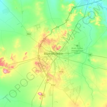
Name: Bloemfontein topographic map, elevation, terrain.
Average elevation: 1,374 m
Minimum elevation: 1,283 m
Maximum elevation: 1,593 m
Make a donation
Gear up for your next adventure:
As an Amazon Associate, this site earns from qualifying purchases at no extra cost to you.
Other topographic maps
Click on a map to view its topography, its elevation and its terrain.
Mangaung Ward 26
South Africa > Free State > Mangaung Metropolitan Municipality
Average elevation: 1,338 m
Rustfontein Dam
South Africa > Free State > Mangaung Metropolitan Municipality
Average elevation: 1,375 m
Bloemspruit
South Africa > Free State > Mangaung Metropolitan Municipality > Bloemfontein
Average elevation: 1,376 m
Wag-n'-Bietjie Park
South Africa > Free State > Mangaung Metropolitan Municipality > Bloemfontein
Average elevation: 1,411 m
Make a donation
Gear up for your next adventure:
As an Amazon Associate, this site earns from qualifying purchases at no extra cost to you.